
Ouachita Trail: Talimena State Park to Winding Stair Recreation Area
29 free downloadable topo maps of the Ouachita Trail. Available for purchase.
The Ouachita Trail begins north of Talihina, Oklahoma on the west edge of the Ouachita National Forest and ends 223 east on Pinnacle Mountain in central Arkansas. On this web page you will find topographic maps with high quality trail renditions for the first 21 miles of the trail. These are the same maps as on the main Ouachita Trail page.
The Maps: All of the maps on this page are nominal 1:24,000 based on USGS 7.5 minute quadrangle topographic maps. Purchased maps are printed in color on 11x17, "Rite in the Rain” all weather writing paper. The hiking trails were mapped with a WAAS enabled GPS and each is drawn in different colors. Also shown are other trails and forest roads not shown on the standard quads. Other features include trailheads, segment mileage, general directions, waypoints and waypoint coordinates.
There are three maps covering the Ouachita Trail from Talimena State Park to the East Billy Creek Trail junction (edge of the Winding Stair Recreation Area). The first section, from the State Park to the Deadman Gap includes part of the Boardstand-Old Military Road Loop and the Talimena Bohannon Loop.
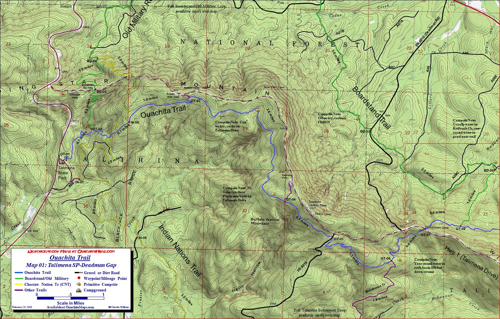 Talimena State Park to Deadman Gap: The Ouachita Trail begins at Talimena State Park, just off of US Highway 271 northeast of Talihina Oklahoma. The trailhead for the Ouachita Trail is well marked and on the east side of the park. Camping, showers and restrooms are available. Tent camping is by resevation and you need to make reservations online. Overnight camping is currently $16 (2025). There ia also a fee if you park there for a backpacking trip.
The trail leaves the trailhead heading east following blue blazes, then curves to north and follows the east side of a small ridge. At 0.7 miles is the junction with Old Military Road Trail (white blaze). Going straight will put you on the Boardstand-Old Military Road Loop. Instead, turn right and climb the back of Winding Stair Mt, a thrust-faulted mountain formed from Pennsylvanian-aged Jackfork Sandstone. Watch for the spring at 0.9 miles.
At 1.1 miles, the Indian Nation Trail crosses the Ouachita Trail for the first time. It will cross 2 more times by mile 1.4. At 2.4 miles is the spur trail to Potato Hills Vista and easy access to Talimena Scenic Drive. While this can serve as an alternate access for a short trip, there are no facilities.
The Frazier Creek campsite, a spacious, wooded one-tent site (you could force more) with abundant rock furniture and a big fire ring is at 3.5 miles. Though water is often available, this campsite can be dry until the fall rains come. Cache water up the draw on Talimena Drive. The Panorama Vista campsite is at 4.8 miles. It has room for several tents but is dry. Cache water at Panorama Vista on Talimena Drive (no facilities). The junction of the Panorama Vista Spur is 0.2 miles past the campsite.
At Forest Road 6010 (5.8 miles), go straight across the road and bear southwest following blue blazes. If you are not paying attention, you might end up on the prominent unblazed trail that goes downhill to the southeast.
At 7.1 is the junction of the Bohannon Trail. Following it south and downhill will connect you to Indian Nation Trail and return you to Talimena State Park, part of the Talimena Bohannon Loop page. Instead go straight. To the right is an east facing nose that has plenty of flat spots for a tent. The trail drops down a hill and crosses Bohannon Creek(7.3 miles). It is you water source and is usually flowing. If the creek is dry, you will likely find water in a rock basin below the crossing. A few hundred feet later is a single-tent site with lots of rock furniture and a fire ring.
The Ouachita Trail crosses Talimena Drive at 7.9 miles. If this is the end of your hike, turn left leaving trail and walk along the drive for 0.2 miles to Deadman Vista.
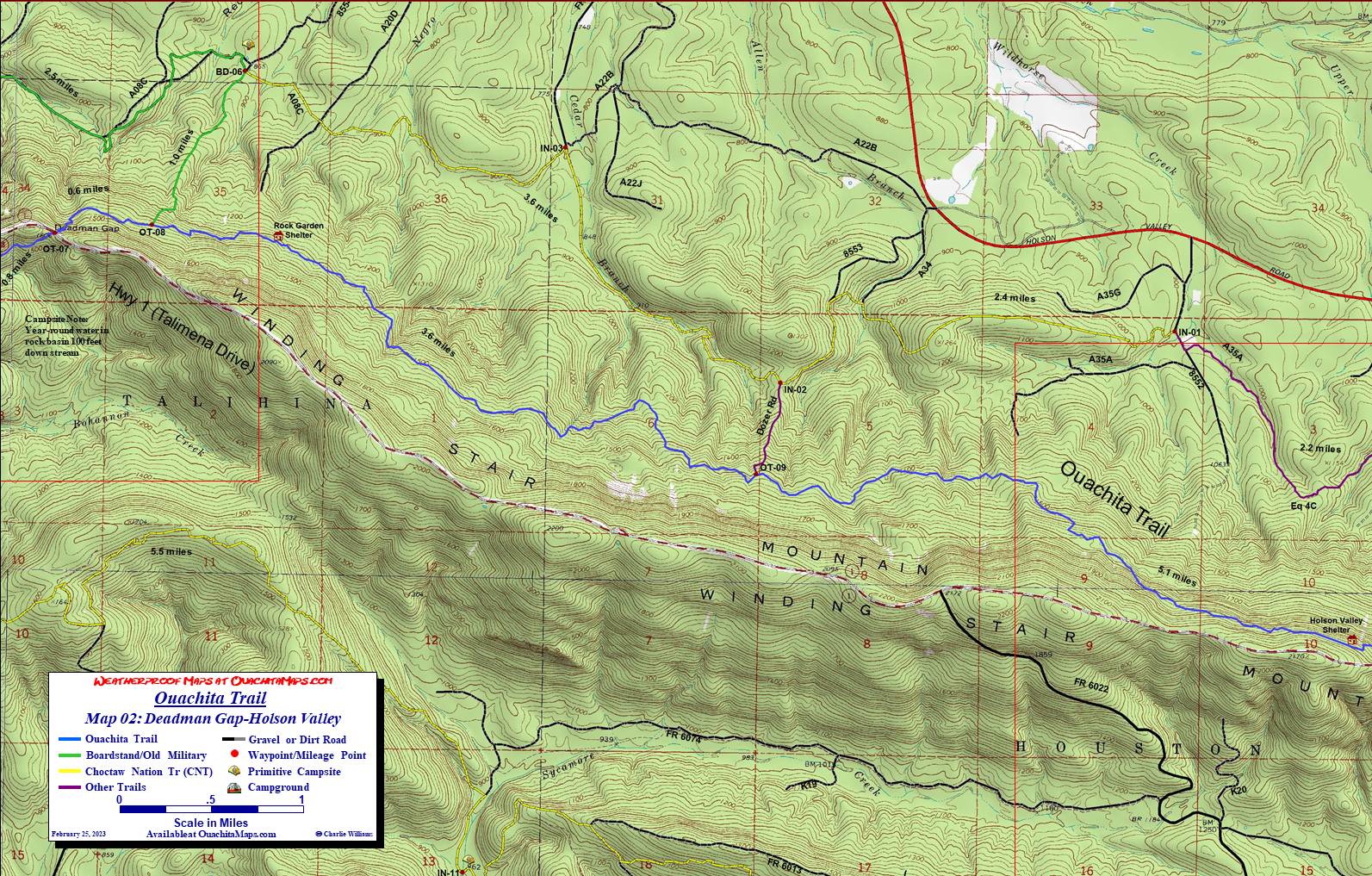 Deadman Gap to Horse Thief Spring: This section is also covered by the Holson Valley Loop page and the Horse Thief Springs-Billy Creek page. These maps are convenient because they offer several different loop trail options allowing you to do sections of the Ouachita Trail without needing a shuttle.
From Deadman Gap, head down the north flank of Winding Stair Mt for 0.6 miles to the junction of the Boardstand Trial. The Boardstand offers two opportunities. First, you can follow it all the way back to the west and pick up the Old Military Road Trail. It, in turn will lead you south back over Winding Stair at Old Military Road Vista and back to the Ouachita Trail at mile 0.7. Alternatively, at the bottom of the mountain, the Boardstand also intersects with the Indian Nation Trail, which if taken east can be used to make some of the aforementioned loops.
Since this narrative is about the Ouachita Trail, stay on it and keep going east. The next 3.6 miles follows a series of benches about half way down the north side of the Winding Stair Mt. The only difficulty in this section of trail is it can be very rocky. We dubbed a couple sections "Ankle Break Pass". (Not a pass, no breaks or sprains, but it felt right). At 12.1 miles is the Dozer Road that leads down to Forest Road 8553 and Holson Valley Road. The Dozer Road has a berm at the bottom and cannot be accessed by vehicle. However, it can be used to connect with the Indian Nation Trail. Go west on the INT and close the loop with the Boardstand. Go east and make a loop that will ultimately join the Horse Thief Springs Trails and, finally, the Ouachita Trail.
Still staying with the Ouachita Trail, continue an eastward hike along terrain similar to the previous section. At 17.2 mile, the West Horse Thief Trail will intersect from the north. This is one of the places you can rejoin the Ouachita Trail if you are on one of the Holson Valley loops.
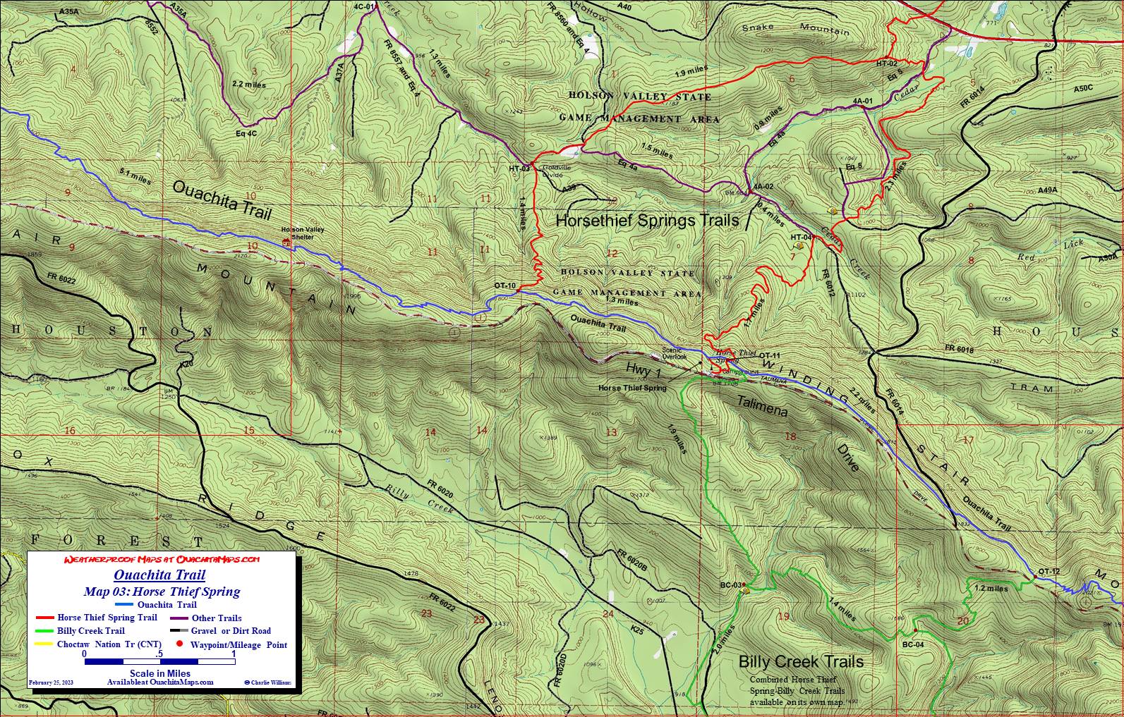 Horse Thief Spring to Winding Stair. At 18.4 and 18.5 you'll hit the west and east spur trails to Horse Thief Spring, a year-round water source. The East Horse Thief Spring Trail joins the Ouachita Trail near the east spur trail. The west Billy Creek Trail also intersects the east Horse Thief spur trail. The Billy Creek Trail is a trail network on the south face of Winding Stair Mt and shares a map with the Horse Thief Springs Trail.
From the east spur trail of the Spring, it is 2.2 miles to the junction of the East Billy Creek Trail. The Ouachita Trail runs near the top of the Mountain over this section, just below Talimena Drive. The Winding Stair-US 259 map picks up the Ouachita Trail at the West Billy Creek Trail junction (20.7 miles).
Shuttles: Hiker shuttles are available from D&W Store (also known as Big Cedar Store, 918-651-3230), Big Cedar RV Park (918-651-3271) and Talking Talking Trees Campground (918-653-2187). Be sure to call ahead and make arrangement as neither is set up for drop in business.
Directions to Talimena State Park: Take US Hwy. 271 seven miles north east of Talihina OK. Turn right at the park entrance.
The Maps: The maps provided here are free to download. They are 1:24,000 based on USGS 7.5 minute quads and formatted to print on 11x17 paper.
To Buy Map: Color weatherproof versions (11x17) of each map are available for $5 each plus S&H by emailing Charlie at cew5151@gmail.com (you will proably need to cut and paste the address into your email app).